
New Brunswick Neighbors by Parcel
A neighbor is a geographic relationship, not a personal or legal relationship. Start with the parcel that contains the address, then identify the adjacent parcel edges at a stated map date. The next step is to determine what the public source actually describes: a map feature, tax block, dated owner field, recorded instrument, historical building, or community context. Keep direction and source date with every result. A nearby map label does not establish who lives there.
| Source | What it shows about a block | Access |
|---|---|---|
| Middlesex Parcels MapServer | Parcel polygons, tax blocks, and adjacent-feature geometry | Public REST service; live query details need confirmation |
| NJGIN Property Explorer | Address, county, municipality, block, lot, and parcel-map context | Public explorer with edge-match and redaction limits |
| Annual tax data | Dated parcel owner, value, and classification snapshot | Public annual data; later transfers can lag |
| Recorded maps and deeds | Lot creation, surveys, instruments, and historical party trail | County index and record-room route |
| Directories and Sanborn maps | Dated household or building context when surviving | Library, archive, and public-map collections |
Owner, occupant, grantor, grantee, and mailing contact are different record roles. The public material may support one of them at a particular date, but it does not turn a block into a list of people.
New Brunswick Neighbors Tax Blocks
The Middlesex public Parcels MapServer separates Parcels and Tax Blocks. It advertises JSON, geoJSON, and PBF query formats with a 2,000-record maximum. The research inspection did not expose the live popup fields, query parameters, export controls, or a ready-made neighbor tool. That means the service supports a parcel-and-block method, not a claimed automatic roster.
Label the map feature before using it. A parcel represents a property geometry; a tax block groups assessment geography; a right-of-way or building footprint is something else. Record the source layer and date. Where an address falls near a corner, keep both street frontages and the block and lot in the research log.
The assigned Middlesex parcel-service image shows the official public service used for the block layer.
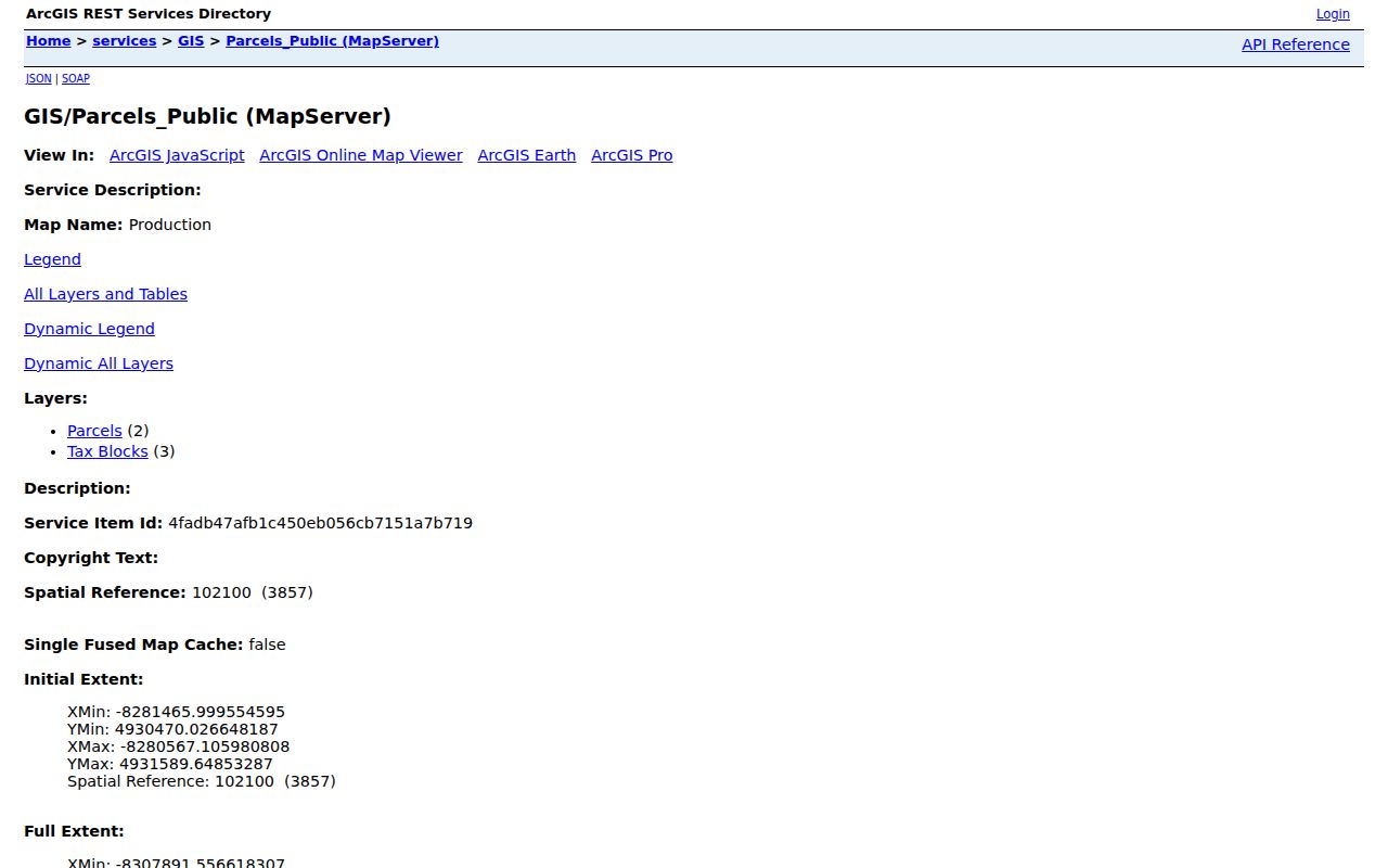
Use the service as the first evidence layer, then corroborate a boundary with a recorded map or other dated source.
Note: The service describes layers and query formats, but its live popup fields, export controls, and built-in neighbor-search behavior need confirmation.
New Brunswick Neighbors Parcel Edges
NJGIN Property Explorer works from address, county, municipality, block, and lot concepts. Its state guidance warns that county parcel boundaries may not edge-match. An apparent shared edge on one map layer can therefore need a check against the county layer, a recorded subdivision map, or the legal description. Do not redraw a boundary or call it exact when the source does not provide a survey.
Daniel’s Law also matters to the block view. New Jersey has redacted owner names from hosted parcels, tax-list downloads, map services, and applications for protected covered people. A missing owner field does not prove that no owner exists. The annual property-tax data is a snapshot, and a later change in ownership may not appear until the next annual file.
Map New Brunswick Neighbors Nearby
A careful block walk uses four evidence layers: the parcel edge, a recorded map or deed, a historical address source, and public community context. The flow keeps the current map from being mistaken for an old street listing or a social connection. Parcel geometry identifies adjacency, while dated records explain the role and period represented by each name.
- Enter the full address in the county or state parcel tool and record the parcel, tax block, lot, map date, and municipality.
- Identify each parcel that shares an edge or is separated only by a public right-of-way. Record direction rather than assuming every nearby feature is adjacent.
- Check a recorded map, deed legal description, or county instrument for lot creation and historical changes. A map or release is not an occupancy record.
- Use a directory, census source, or Sanborn sheet for the relevant historical date. Mark a result as parcel, owner, listed occupant, map use, or community context.
For a full named-street chain instead of the immediate block, use the New Brunswick street directory. It follows address-keyed sources across a street without turning a neighbor search into an unsupported household list.
New Brunswick Neighbors Geography
Neighborhood names make a block easier to place, but they are not legal parcel boundaries. Public-facing descriptions use City Center, the Rutgers and College Avenue or Easton Avenue corridor, Esperanza and French Street, Hungarian community references, south neighborhoods near Douglass, Cook, and Unity Square, and the Raritan River edge. A legal municipality, street address, ZIP routing label, and tax parcel can all use different boundaries.
New Brunswick’s compact area also contains county government, university, medical, civic, religious, business, and residential parcels. A large institutional parcel can have several tax lots. Map the parcel group and the organization’s public property or entity record rather than treating each building label as a separate household. Historic map context can show a building use, but it cannot identify a current resident.
Direction is a useful check on New Brunswick neighbors. Note whether a parcel lies north, south, east, west, across a right-of-way, or at a corner. A corner parcel can carry two street names, a former address, or a postal line that differs from the road on the map. Search both frontages and the legal description. A rear lot or alley address may appear only under the main street or lot number.
Note: Preserve postal label, legal municipality, parcel, and street fields separately because they can describe the same place in different ways.
New Brunswick Neighbors Community Context
New Brunswick Tomorrow describes resident-driven, place-based neighborhood engagement. Its public neighborhood material is useful for understanding local terms and community work around a block. It is not a membership directory, and the research found no comprehensive public roster of neighborhood associations or private memberships in the city.
Use an organization page to add public context after the map and historic records have established the place. It cannot establish that an individual lived in, joined, or represented an organization. The safest record note names the organization, public page, place context, source date, and the fact that no member roster was located.
The assigned New Brunswick Tomorrow image links to its public neighborhood work.
That public context can help label a neighborhood without replacing parcel evidence or exposing private membership information.
New Brunswick Neighbors Historic Maps
The February 1897 Library of Congress Sanborn map has 31 sheets. It can show a former building footprint, use, street relationship, adjacent business, church, school, alley, or water and fire feature. Pair it with a modern parcel map because street geometry, lot lines, and buildings can change. A missing modern neighbor can be a removed structure or a reconfigured parcel.
Read the historic sheet as a dated fire-insurance map, not a survey or resident roster. The strongest comparison pairs the sheet with a directory entry, a recorded map, and the current parcel. Preserve the sheet, date, printed address, and whether each feature is exact or approximate. A historical building use may explain why a street number is now institutional or absent.
Note: A Sanborn sheet can explain historical surroundings, but it cannot prove a current occupant or a personal connection between people on adjoining properties.
New Brunswick Neighbors Civic History
The Civic League of Greater New Brunswick is an independent nonprofit that has served the area since 1945. Its public contact is 47–49 Throop Avenue, with phone 732-247-9066. This gives a block researcher a public community-history contact, not a source for private member names. Its material can place public programs and institutions in local context.
The assigned Civic League image points to the organization’s public contact and program information.
For older institutional context, Rutgers, the State Archives, and the Middlesex historical division may hold records that name a collection or historic program without creating a current neighbor directory.
New Brunswick Neighbors Source Roles
Official records and commercial neighbor tools differ most in provenance. Official sources identify the custodian, date, record type, and access limits. Commercial categories can combine old or unclear data, while the research did not verify their sources, update dates, or matching rules. Use the official parcel, tax, map, and record-room route when the goal is to document a block relationship.
| Official record route | Commercial neighbor category | Practical difference |
|---|---|---|
| Names the agency, date, and record series | May present combined entries without a clear custodian | Official provenance supports a check against the original source |
| Shows a defined role, such as parcel or dated owner field | Can blur owner, occupant, or historical listing | Role labels prevent a false household inference |
| Has stated privacy and redaction limits | May not explain why a field is blank or old | Redaction and update limits remain visible |
Use the four-layer worksheet for every block: parcel edge, recorded map or deed, historical address source, and community context. Attach a confidence label only to the geographic relationship supported by those layers.
New Brunswick Neighbors Privacy Limits
New Brunswick public parcel data does not make every household detail public. Protected owner names may be redacted under Daniel’s Law. The Address Confidentiality Program provides a substitute address for qualifying people, and motor-vehicle data is separately restricted. Utility customer lists were not located as public sources. A voter or tax record can also be stale, restricted, or tied to a different record purpose.
New Jersey Open Public Records Act requests should identify a specific record category, address or parcel, date, and custodian. The OPRA guidance explains that access can involve exemptions and redaction. The proper correction or privacy route begins with the agency that holds the exact record, not an assumption that a map result should be complete.